Using Augmented Reality to Visualize Engineering Designs

This week I experimented with using an augmented reality app at a public meeting to display this simple visualization of one of our projects.

3D model of a project using Augmented Reality

My experience was that it did seem to help with explaining or showing people not only an overall snapshot of how the roadway will look when finished, but it also helped show specific design and operational details that were difficult to describe. So I figured I'd post a quick explanation of the software I used to create the model and which app I used to host and display the visualization in case anyone else is interested in trying something similar out at their own meetings.

To begin, I would have liked to just export the project directly out of CAD and into the program where I assembled the 3D model because this allows for a more accurate representation and saves some steps. I've done this before using AutoCAD, and it was very straight forward and easy. Unfortunately we use Microstation at work instead of AutoCAD and so far I have been unable to find a way to get this to work with that software. The main problem seems to be that although it has 3D export capability, the program will not allow me to export something with a thickness so everything ends up flat. And it won't let me expand my export in the "Z" direction even if I import it into other 3D programs. I've spoken with a representative of the company, and as I've indicated in previous posts, he said Microstation is not interested in supporting this because they don't see a need for engineers to use this type of feature – as he put it "we're engineers, not gamers." So because of this, I had to create the 3D objects in other programs and use a PDF of the plan view as a guide in placing the objects. Also because of this and my time constraints I only modeled a portion of the project where there were no complex shapes.

So the program I used to create and assemble the 3D objects is Opensimulator. It's a free, open source program that runs as a web service and allows you to create and texture 3D objects then export them as models. You can set up Opensimulator on your own desktop by using something like SimonaStick or you can run it by installing it on your computer and connecting it to a service that allows you to access the interface with the use of a viewer. I used the second option and connected it to a service called OSGrid then used the Singularity viewer to log in and build. The main difference between building with this method and one that would use a more traditional 3D program like Blender is that building in Opensimulator is much more intuitive because you create using an avatar or 3D representation of yourself. Opensimulator has also greatly simplified the creation and texturing of objects.

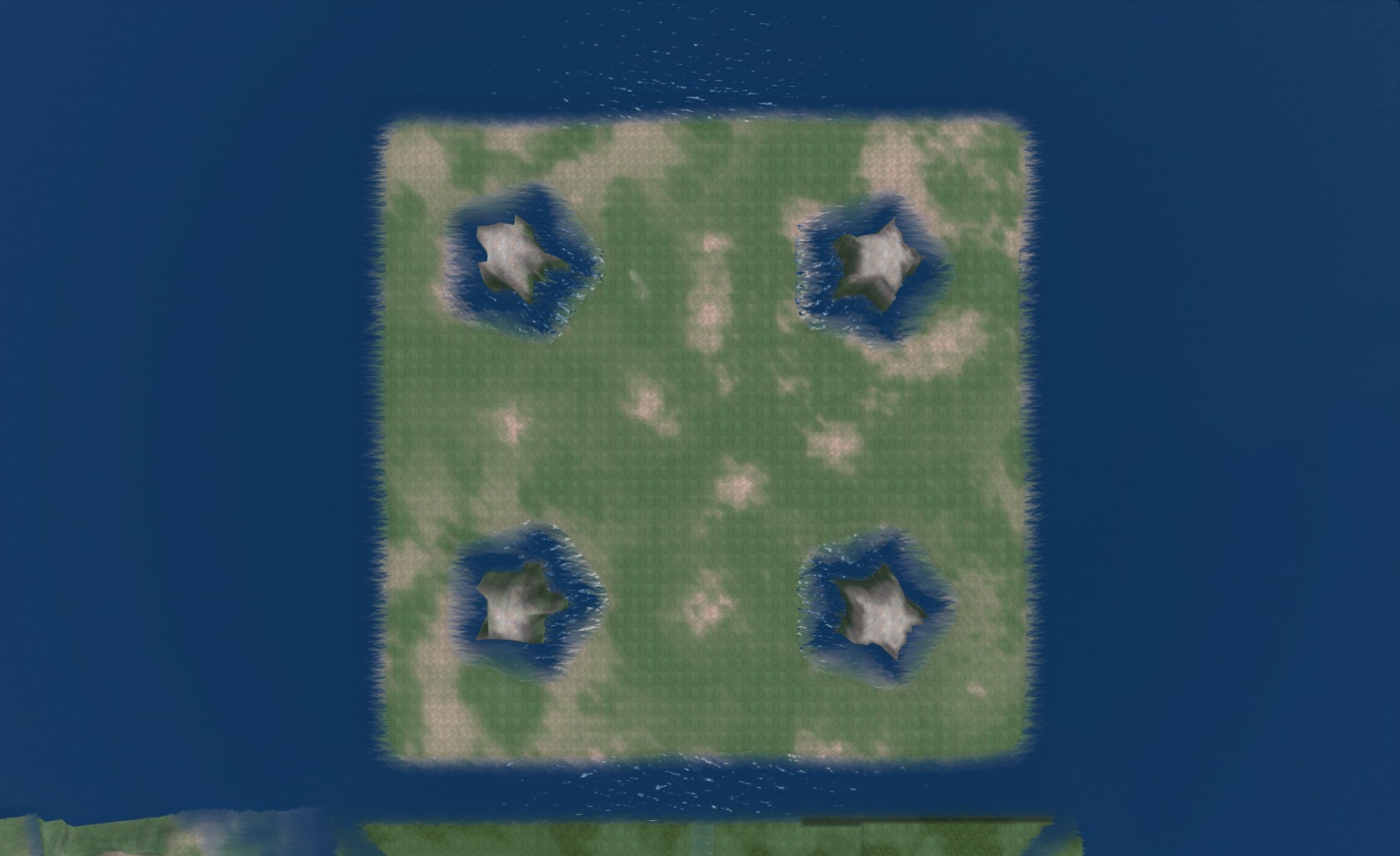
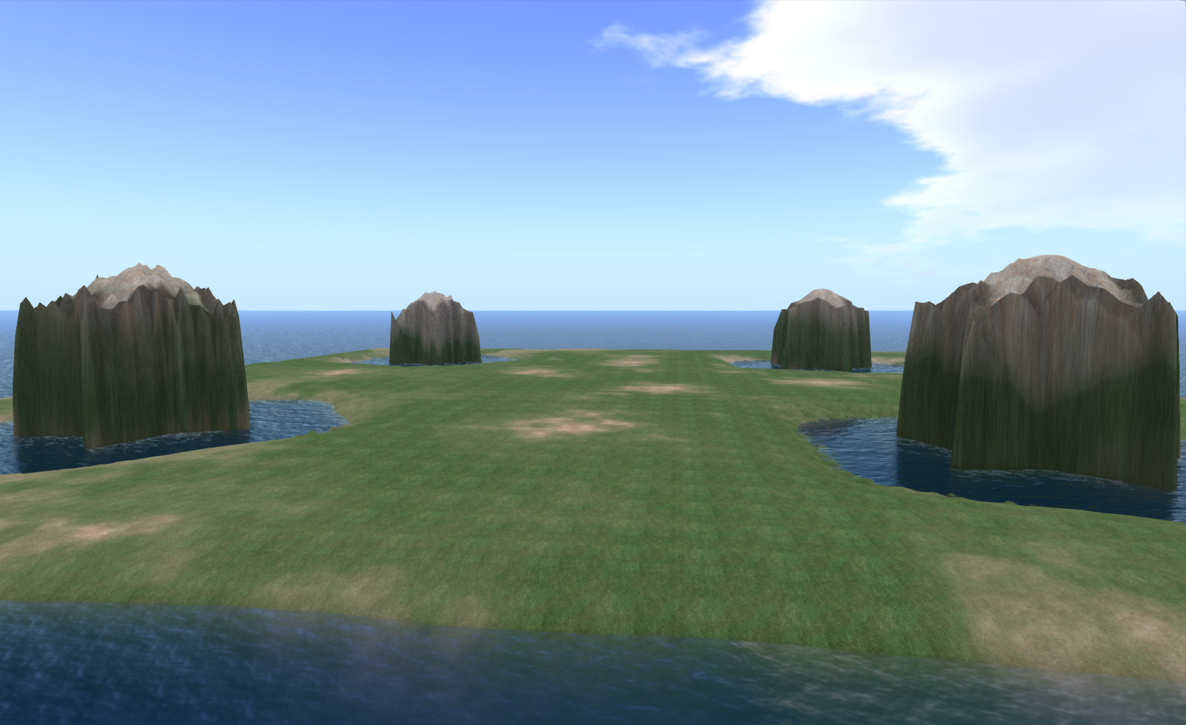
Here is an "aerial view" of what my "build" looked like inside OSGrid right before I exported it as a 3D model.
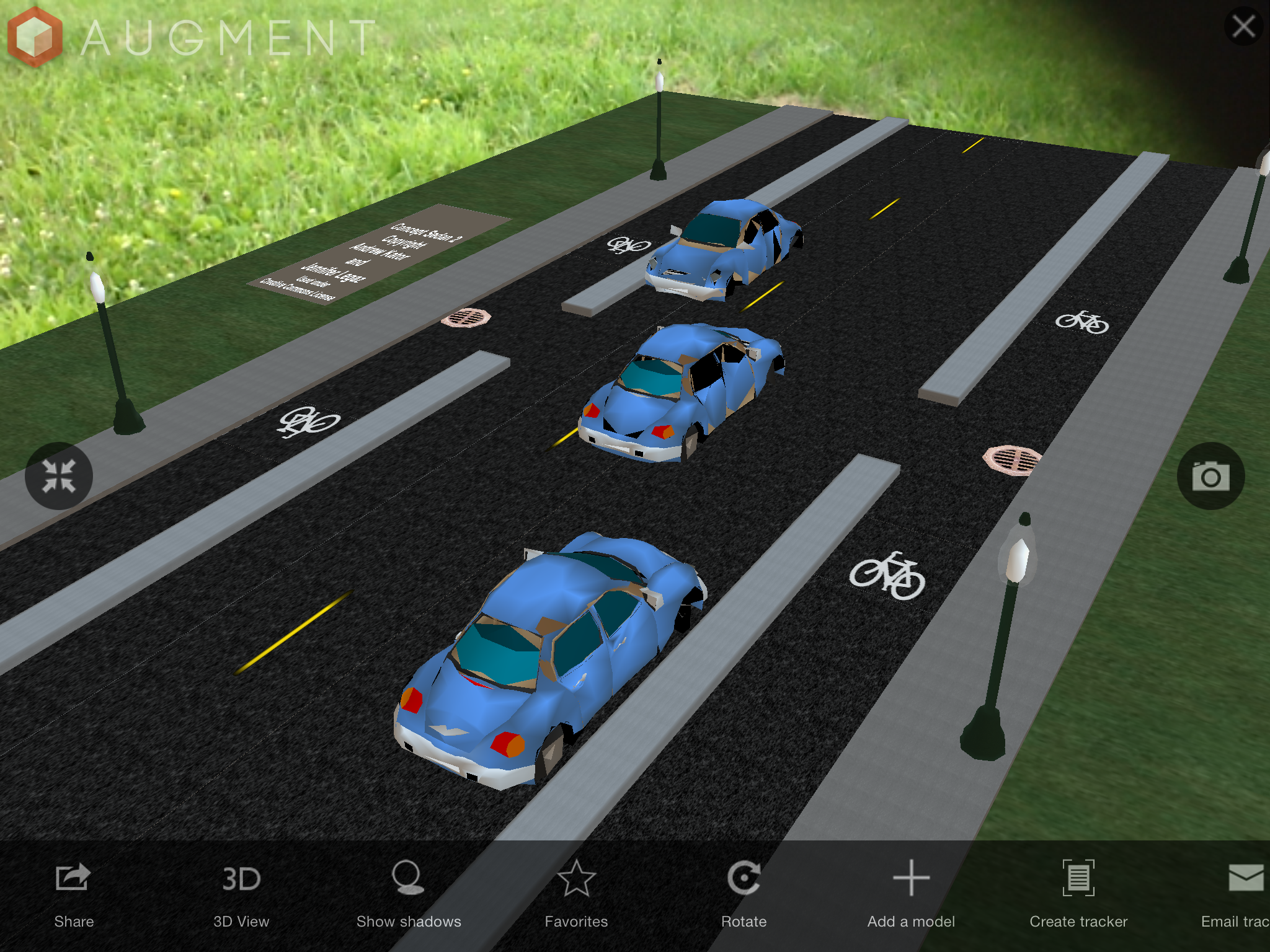
As a side note, what is nice about building in Opensimulator is that you can use your avatar to walk through the project and get a feel for how it will function. If we were also building a streetscape, the use of an avatar helps assist in placement of elements. And from what I understand, if I had an Oculus Rift device, I could have put it on and immersed myself in the design as if I was actually there. This is something I hope to also eventually try as a design tool once I get a chance to buy one of those devices.

The only elements in the photo above that I could not create in Opensimulator were the cars and curbed medians. As you can see from the attribution note in the photo, the cars were 3D models I downloaded from the Kator Legaz website then uploaded into Opensimulator using Singularity. And I also uploaded a median that I created in Blender because I wanted the top to be curved like a regular curb is – Opensimulator does not allow for the creation of something like this so I had to use Blender then import the 3D model into Opensimulator. For all the graphics or textures applied to the models, I created them using a graphic software package then uploaded them into Opensimulator. There are many graphics programs that I use, but if you are looking for a good, free program, you can always use Gimp.

Once everything was assembled, I used the export 3D model feature in Singularity to create a Collada file of my build. Then I used my account on Augment to upload the model so I could access it and view it using the Augment app on my iPhone and iPad. Having the model available at the meeting made it convenient to show people what it will look like when built. For example, when I was having trouble explaining how the inlets impact the bike lane, I was able to just use this model to show someone how the inlets effectively reduce the bike lane from 7.5 feet in width to 5 feet if people do not want to ride over the inlet. Overall I would say having the model did enhance the ability to share our project with the community, and I hope to be able to build upon this experience to create more complex and detailed models in the future. If you want to check out the model yourself, you can access it here:

3D Model of Protected Bike Lane

Share

Augview – a Window to Your Underground Assets


Water Main Installation

Augview, founded by Michael Bundock in 2012 in New Zealand, is the first commercial, mobile application I have seen offered to the public works industry allowing utilities to geospatially capture, store, and display underground utilities in 3D through the use of a tablet or other mobile device. The software, through the use of GIS, will show operators their water, sewer, or other underground lines superimposed in 3D upon the ground in a geospatially accurate position. Users can then query the lines as with any other online GIS and access data about that utility such as size, material, age, and any other type of stored data. Or if a locator finds a discrepancy in a line's location or if he finds a new line, he can enter it into the software and immediately verify the updated or new location is accurate.

One example I can think of where I could have used this type of device was when we found a patched area in a roadway on one of our projects. It was one of those typical failures you find where you can see someone repaired something, but there's still something going on because a small hole opens back up with a void underneath. A lot of times this is caused by a hole in a sewer which allows soil above the pipe to wash away into the line leaving a void under the pavement. I knew the city had a sewer running along the roadway near that area, and I noticed a water shut off box nearby in the parkway. Because in our area the sewer lines used to be run with the water lines, I suspected it could be a failure with the building sewer. The business owner came out to comment on it and mentioned there had been a problem there, but it was difficult for me to tell for sure from what she explained if it had been the city sewer or the building owner's line. If I had Augview, I would have seen how all these lines related and where they were located. This visualization would have offered a better prediction of exactly which line could possibly have a failure. Of course public works professionals already try to make this determination using paper maps, but if it was the building owner's line, it is much easier to explain the problem to them using a 3D representation of everything rather than expect them to read a utility atlas.

I would have also liked to have an application like Augview for management of our water network. Our crews could have used the application to document the valve position when they opened or closed it. Then we could have just driven by to see if we had opened them all back up after we repaired the break, or we could have noticed when a valve between our pressure zones accidently was opened.

It would also be useful to use Augview to look at non-utility data for something like visualizing roadway ratings in the field. Then each year when we went out to rate the roadways, perhaps Augview could color the roadway based on the rating we assigned the year before in our GIS. This would prevent us from juggling paper maps in the truck while we are trying to also view and assess the pavement.

Past articles on this site have also imagined one day a product like Augview could be used to assist contractors as they build by displaying not only the underground lines but actually superimposing the plan onto the site. And I don't think it will be long before this type of implementation is extended to allow us to display real time data too. I can see one day we will be able to look up at the water tower and actually see the level of water in it or be able to see an indication at our water or wastewater plants of the flows running in and out and through each process. It would also be interesting to be able to drive by our lift stations and see the whole area colored red or green rather than just see the little red/green run light. This is also another facility that could display flows, seal failures, water levels or any other type of data.

While at the present time Augview has primarily been implemented in New Zealand, Melanie Langlotz,  business development manager, said she is "also looking for interested parties in the U.S. who can see the possibilities." So I believe it won't be long before we see Augview in use throughout the U.S. and other countries.

You can find out more about Augview by watching the video below or visiting their website or other social media sites:

Share

Free 3D Software for Civil Engineers

If you regularly read this blog, you already know we strongly believe 3D visualizations and environments will play a big role in the future of civil engineering. Over the last several years we've seen an increasing use of 3D products to help people better plan and build large-scale developments and structures. Last year, FHWA incorporated 3D into their Every Day Counts initiative, and recently President Obama announced the launch of two new digital manufacturing hubs. It's interesting to note the President's weekly address this week covered those launches along with a push for innovative infrastructure – one day, in our industry, both topics will most likely be closely aligned. But like any change or new innovation, there are naysayers and those who resist the transition, and there is little we can do to change their mind. Like the old draftsman clinging to his ink pen and Leroy set, they will be left behind. Instead of worrying about convincing them, we wanted to reach out to all of you who are looking forward to the future yet might not know where to start or to those of you who might be wondering how to pick up some 3D skills without having to spend a lot of money. Below we've listed several programs available for free or at a low cost. They are grouped by complexity of the software.

Introduction to 3D

Autodesk 123D – an Autodesk suite of free 3D software:

While Autodesk's flagship products like AutoCAD and 3ds Max might have a price tag out of reach for most of us, the company fortunately offers several free products you can use to build your 3D skills. You can even use most of these programs to create a 3D print of your creation! Here's a list of each program you can try out:

123D Catch – a computer, web-based, or mobile-based program allowing you to transform a photo into a 3D object

123D Design – a computer, web-based, or mobile-based program allowing you to create 3D designs

123D Creature – a mobile-based app allowing you to easily create a 3D creature

123D Sculpt – a mobile-based app allowing you to easily sculpt 3D models

123D Meshmixer – a computer-based program allowing you to develop 3D models

Tinkercad – a web-based program allowing you to create 3D models (this is free for personal use at this time, but may in the future transition to a low-cost subscription based program).


SketchUp – SketchUp Make is the free version of the popular 3D modeling program now owned by Trimble.  

Sketchup Interface


3D Tin – this free, web-based program allows you to easily create 3D models. You can save and export them and even send them to a 3D printing site. The key thing to keep in mind before using this site is that it requires a specific type of browser. I was able to use the most recent version of Firefox to access it. Below is the screenshot of a few 3D letters I easily created with the object-based tools. 


3D Tin Interface


MakeHuman – this is a free, computer-based program that allows you to create human 3D models. 

tree[d] – this is a free, computer-based program that allows you to easily create 3D models of trees. Below is a screenshot of the interface.

tree[d] interface


Intermediate Level 3D

The following programs will most likely require a little more effort to learn than those in the introductory category. Fortunately you can usually find your way around the software by making use of the tutorials and community forums available for each program:

Seamless 3D – this is a free, computer-based program that allows you to create 3D models. Below is a screenshot of the interface.

Seamless3D Screenshot


Sculptris – a free computer-based program allowing you to create 3D organic looking models


AC3D – a low-cost, computer-based program that allows you to create 3D models. At this time, the cost for one license is $89.95. Below is a screenshot of the interface.

AC3D Interface


Wings3D – this is a free, computer-based program that allows you to create 3D models. Below is a screenshot of the interface showing a model I uploaded of a creature I made using the 123D Creature software on my iPad.

Rendering in Wings3D of a creature model

RaySupreme 3D – this is a low-cost, computer-based program that allows you to create 3D models. At this time, the cost of the software is $39.99. Below is a screenshot of the interface showing a rounded cube.

Ray Supreme 3D Interface


Clara.io – Thanks to Mimetic Core for bringing this site to my attention after I posted this article. The site is in beta, but is very functional and easy to use. I am listing it as intermediate since it appears to offer more advanced 3D features than those included in the Introductory section. This is a free, browser-based program that allows you to create 3D models after you register on the site. There are also several pre-made models available for you to load and edit to get used to the software. You can see the ladybug model in the screenshot below.  

Clara.io Interface

Second Life / OpenSim – I'm including these free, computer-based programs even though many in the industry would not probably think of these as 3D modeling packages. This is probably because while both programs have always allowed people to create 3D models, until last year, whatever people created could not be exported for use in other programs. Fortunately within the last several months, a third-party developed the ability to export models created in these environments. So now, people can use the building tools in Second Life or Open Sim environments to easily create a 3D model and then export it. And even though the building of the model is relatively easy, I put the program in the intermediate category because the interface is much different than any of the other programs listed here and might take some time to get used to. This is because instead of just installing a software package and using the commands like a regular program, people build in Second Life/Open Sim by entering the software through an avatar or digital representation of themselves. I included a screenshot of the interface below showing my avatar building a basic cube in Second Life.


Second Life 3D Modeling Interface


Advanced Level 3D Modeling

The programs below are more involved than those listed above. Usually they have more advanced features and the interface is more complicated to navigate. While it will take some time to learn these programs, there are many tutorials and resources available online to help teach you what you need to know to use them.

Blender – this is a free, computer-based program that allows you to create 3D models. Blender is a very advanced tool with complex features including the ability to animate objects and create scenes, video games, and movies. Because of this, it does take some time to learn this program. Fortunately there are many resources and tutorials available.

Blender Interface


DAZ 3D Suite of Products

In addition to their higher cost 3D program, Carrara (which is still fairly low-cost at $149.95 and $285.00 for the pro version), DAZ 3D offers several free and low-cost programs. Occasionally they have also allowed a free download of their products for limited times throughout the year. While you might have to devote more time to learning how to use these programs, there are many sites out there offering videos and tutorials to help you learn. 

Hexagon – this free, computer-based program allows you to create 3D models. Below is a screenshot of the interface showing a basic 3D object.


Hexagon Interface

DAZ Studio – this is a free, computer-based program that allows you to create 3D models, scenes, and artwork along with animations and poses. While I've posted this in the advanced section so it could be grouped with the other Daz products, DAZ Studio is actually very easy to use. Below is a screenshot of the interface. My main use of it at this time is to create poses for 3D models of people.


DAZ Studio Interface

Bryce – this is a low-cost (at the time of the post it was selling for $19.95) computer-based program that allows you to create 3D environments


Unity3D – this is a free, computer-based program that can be used to create 3D models. However, most people seem to be using this program to develop 3D environments into which they place 3D models made in other programs. Unity3D is a full-featured, advanced software package that takes some time to learn. Like the other programs listed in this post, there are many sites available online where you can find tutorials and other educational resources to help teach you how to use it. There is also a higher cost pro version of the program available, but most people can get by using the free version – particularly if you are just trying to become familiar with 3D modeling. Below is a screenshot of the interface of the free version showing a scene I created by following a tutorial.

Unity3D Interface


(Post updated March 2, 2014 to add Clara.io site)

Share

The Game is On – FHWA is Seeking Your Input on Smart Cars

USDOT Connected Vehicles ImageThe USDOT and several other transportation agencies around the nation have been paying close attention to the emergence of the smart car. Over the last few years, they have funded research in this technology and studied how to integrate it into the existing system. And now, they are reaching out in several ways to share what they have learned and seek input from the public and other professionals to help develop guidance for connected vehicles. Here is an excerpt of the notice from FHWA:

"The Federal Highway Administration plans to issue deployment guidance on connected vehicles to transportation infrastructure owner/operators in 2015. Your input is needed. Tell us what would best support decision making and deployments at the state and local level."

You can read more about this effort and access the link to provide your own thoughts and ideas at http://www.its.dot.gov/connected_vehicle/fhwa2015_connected_vehicles.htm. (The link to provide input was not working for me so if it does not for you, here are the email addresses it is set up to link to: Robert.Arnold@dot.gov and Cynthia.Maloney@dot.gov.) FHWA also collected public input at a session held on Jan. 16, 2014, in Washington, D.C. As the proceedings from that meeting become available, they will also be provided at that site.

Before providing input, FHWA suggests people read an article in Public Roads, Linking Drivers and Roads, to get more background on the technology and potential benefits which include the ability to:

  • deliver more accurate and robust hazard warnings to drivers
  • collect data for use in improving the transportation system
  • deliver vehicle location and speed information to traffic signals to adjust phasing and avoid vehicle idling
  • deliver road conditions to State and local agencies to help improve maintenance and service
  • deliver traffic and transit information to help travelers select optimal routes
  • provide specific, dynamic warnings that are more reliable than static signs and more likely to capture drivers' attention
  • provide invehicle alerts to drivers about potential violations of upcoming red lights
  • alert motorists when it is unsafe to enter intersections
  • alert the motorist to slow down if a driver's current speed is unsafe for traveling through an upcoming road curve
  • implement crash avoidance systems
  • inform visually impaired pedestrians of when to cross at intersections and how to remain aligned with crosswalks
  • allow for smartphones of registered blind users to alert traffic signal controllers and drivers to the presence of visually impaired pedestrians waiting to cross
  • enable granting buses priority at traffic signals based on factors such as number of passengers, schedule and headway adherence, service type, and peak direction of travel
  • provide travel information to commercial vehicle operators, including freight-specific route guidance, and facilitate coordinated load management to reduce empty-load trips
  • facilitate integrated transit operations, such as passenger connection protection, transit dispatching, and new forms of operational practices intended to enhance dynamic ridesharing

Another interesting section in the article summarizes the studies funded by FHWA and provides links to their findings.There are at least five other resources cited where you can learn more about this technology.


I've included a few more resources below for those who are interested in reading more about this technology:

USDOT Connected Vehicle Research Page: http://www.its.dot.gov/connected_vehicle/connected_vehicle.htm

Videos discussing connected vehicles from the opening session of ITE 2013 Annual Meeting and Exhibit in Boston, MA. http://www.ite.org/connectedvehicle/openingsession.asp

Tom Bamonte Twitter Stream (Tom regularly posts links to stories about driverless technology) : http://twitter.com/tombamonte


Share

Resources for Developing your 3D Engineering Skills


Roadway Design Visualization - Natchez Trace Parkway, MS


If you've been paying any attention to the Every Day Counts website, you might have noticed that 3D Engineered Models are now being promoted by the Every Day Counts program. This is because of the potential for this type of technology to cost effectively accelerate construction. However, in addition to this, 3D engineered models offer many other benefits including the ability to better plan and visualize designs and enhance public outreach. If you or your agency or firm have not yet integrated 3D models into your process and are interested in learning more about this technology, you can check out the growing number of resources posted on the FHWA 3D Engineered Models Website at http://www.fhwa.dot.gov/construction/3d/.

Their site offers links to examples of how 3D models have been used in projects along with links to manuals and other guidance of how to integrate and develop 3D models in your own projects. At the end of last year, FHWA also started a year-long webinar training series. Below is a listing of the topics they are offering. You can view past webinars or sign up for future ones at the link given above.

Future Webinars

Applications of 3D Models in the Construction Office February 19, 2014 1:00 p.m. – 2:30 p.m. Eastern
Applications of 3D Models on the Construction Site April 2, 2014 1:00 p.m. – 2:30 p.m. Eastern
Managing and Sharing 3D Models for Construction May 7, 2014 1:00 p.m. – 2:30 p.m. Eastern
Overcoming Impediments to Using 3D Engineered Models for Construction September 10, 2014 1:00 p.m. – 2:30 p.m. Eastern
Steps to Requiring 3D Engineered Models for Construction October 15, 2014 1:00 p.m. – 2:30 p.m. Eastern
The Future: Adding Time, Cost and Other Information to 3D Models November 19, 2014 1:00 p.m. – 2:30 p.m. Eastern

 Past Webinars

Overview of 3D Engineered Models for Construction November 20, 2013 1:00 p.m. – 2:30 p.m. Eastern
Creating 3D Engineered Models January 8, 2014 1:00 p.m. – 2:30 p.m. Eastern


Source of Photo used in post: Roadway Design Visualization – Natchez Trace Parkway, MS, http://www.efl.fhwa.dot.gov/technology/Road-VS/Natchez-Trace-Parkway/natchez-trace-parkway.aspx

Share

Terrain Files for 3D Worlds

For some time I've experimented with creating terrain for use in 3D immersive spaces. Usually I am trying to alter DEM files to create simulations of project sites. But lately I've started to explore creating specific shapes or designs, and I think I've finally found a work flow that might make the whole process a little easier. Here is a file I created that can be used in a world like Second Life or OpenSim. If you have estate powers, you can go to the estate menu and upload the file as a RAW file to create this land. It is a square measuring 256 x 256 meters with 4 star-shaped hills rising out of star-shaped water features.

Star Terrain Overhead View  Star Terrain Ground View

If you click this file name, you can download the file for your own use. I am releasing it under a Creative Commons license that would allow you to basically use it for anything except selling it as is. Since this is my first time offering a file I created, please let me know if it does not work for you.

[wpdm_file id=2]


Share