Submit Your Ideas on Transportation & Assistive Devices & Technologies

Pedestrian and Signal Technology

The U.S. DOT through the FHWA has opened a dialogue on Transportation and Assistive Devices and Technologies. You can visit their Ideascale site to offer your own ideas about how best to make use of technologies to enhance and support mobility for transportation users with disabilities.

It's important for all of us in involved in roadway and signal design to remain involved in dialogues like this so that new technologies can be integrated in the most efficient and effective manner. Even if you don't want to comment or offer an idea, it's helpful to read through the ideas and comments to learn what those who use facilities we design really need. And there are a few comments that lead to other resources and tools which might be useful to planners and designers.

I offered one idea we've been discussing since visiting a community that had an older APS installed at an intersection. We noticed the voice was difficult to hear and understand. I want to add though that neither of us have a vision impairment so our observation was made as users who often rely on our sight for guidance and therefore could be different that the opinion of a person with a vision impairment. (You can watch a short video we took of the cycle to listen yourself to what a pedestrian would hear at this intersection.)

Other than the inability to really hear and understand what is going on from these devices, we are also aware there is concern about the constant noise created in the environment. While this is useful and necessary when needed, is it best to have a device that continues to make noise in the environment even when not needed? Especially when it begins to compete with other signal device sounds in a highly dense, and urbanized area? 

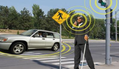
Before smart phones these were perhaps our only solution and therefore necessary, but now with smart devices, we wondered if it wouldn't be better to have pedestrian signal devices communicate directly with smart phones or devices. The APS could activate only when sensing a device that is programmed to request specific information from the APS such as location of button, path guidance, and area location information. If a path or destination had been programmed, perhaps the APS could even signal to the user which direction to go or if they are on the wrong street.

We also talked about installing something in the pavement along both edges of the crosswalk that could communicate with a pedestrian and let them know through vibrations or a pulse they were wandering outside of the crosswalk area.

Since exploring these ideas, we have not yet had the chance to discuss it with anyone who has a vision impairment which is why the dialogue is so important. Perhaps there are issues with our ideas we have not considered since we are primarily the designers and not the users of these devices. So I encourage everyone to take just a few minutes to visit the site, read the ideas, submit your own if you have them, add some comments, and work together with everyone to increase the use and mobility of our designs for everyone. 

Share

The Game is On – FHWA is Seeking Your Input on Smart Cars

USDOT Connected Vehicles ImageThe USDOT and several other transportation agencies around the nation have been paying close attention to the emergence of the smart car. Over the last few years, they have funded research in this technology and studied how to integrate it into the existing system. And now, they are reaching out in several ways to share what they have learned and seek input from the public and other professionals to help develop guidance for connected vehicles. Here is an excerpt of the notice from FHWA:

"The Federal Highway Administration plans to issue deployment guidance on connected vehicles to transportation infrastructure owner/operators in 2015. Your input is needed. Tell us what would best support decision making and deployments at the state and local level."

You can read more about this effort and access the link to provide your own thoughts and ideas at http://www.its.dot.gov/connected_vehicle/fhwa2015_connected_vehicles.htm. (The link to provide input was not working for me so if it does not for you, here are the email addresses it is set up to link to: Robert.Arnold@dot.gov and Cynthia.Maloney@dot.gov.) FHWA also collected public input at a session held on Jan. 16, 2014, in Washington, D.C. As the proceedings from that meeting become available, they will also be provided at that site.

Before providing input, FHWA suggests people read an article in Public Roads, Linking Drivers and Roads, to get more background on the technology and potential benefits which include the ability to:

  • deliver more accurate and robust hazard warnings to drivers
  • collect data for use in improving the transportation system
  • deliver vehicle location and speed information to traffic signals to adjust phasing and avoid vehicle idling
  • deliver road conditions to State and local agencies to help improve maintenance and service
  • deliver traffic and transit information to help travelers select optimal routes
  • provide specific, dynamic warnings that are more reliable than static signs and more likely to capture drivers' attention
  • provide invehicle alerts to drivers about potential violations of upcoming red lights
  • alert motorists when it is unsafe to enter intersections
  • alert the motorist to slow down if a driver's current speed is unsafe for traveling through an upcoming road curve
  • implement crash avoidance systems
  • inform visually impaired pedestrians of when to cross at intersections and how to remain aligned with crosswalks
  • allow for smartphones of registered blind users to alert traffic signal controllers and drivers to the presence of visually impaired pedestrians waiting to cross
  • enable granting buses priority at traffic signals based on factors such as number of passengers, schedule and headway adherence, service type, and peak direction of travel
  • provide travel information to commercial vehicle operators, including freight-specific route guidance, and facilitate coordinated load management to reduce empty-load trips
  • facilitate integrated transit operations, such as passenger connection protection, transit dispatching, and new forms of operational practices intended to enhance dynamic ridesharing

Another interesting section in the article summarizes the studies funded by FHWA and provides links to their findings.There are at least five other resources cited where you can learn more about this technology.


I've included a few more resources below for those who are interested in reading more about this technology:

USDOT Connected Vehicle Research Page: http://www.its.dot.gov/connected_vehicle/connected_vehicle.htm

Videos discussing connected vehicles from the opening session of ITE 2013 Annual Meeting and Exhibit in Boston, MA. http://www.ite.org/connectedvehicle/openingsession.asp

Tom Bamonte Twitter Stream (Tom regularly posts links to stories about driverless technology) : http://twitter.com/tombamonte


Share

Infographic of the Month – September 2013

This month we have a bike-related infographic supplied by Online Masters in Public Health. Whether it's to improve health or save money, people seem to be hopping on their bikes more than ever. And cities and states are working to accommodate these increased demands for bicycle facilities. As the Infographic shows, one initiative experiencing great success throughout the U.S. is bike sharing.

An infographic by the team at Online Masters In Public Health

The Public Works Group tries to highlight at least one infographic a month related to any public works topic. So if you've got 'em, send 'em!

Share

Balancing – the key to a successful bike sharing program

Bike Sharing Station in Denver ColoradoMost major cities have implemented some level of bike sharing programs in their community. And based on usage reports, these programs have shown to be well received by people in these communities. The idea behind the setup is fairly simple: install bike docking stations at key locations through a city and allow people to rent the bikes using self-pay kiosks. Users pick up the bikes from one station and deliver them to another near their destination. The result is a convenient and relatively low-cost transportation alternative that does not add to existing congestion levels. 

Setting up the program can be easier than planning and constructing more traditional infrastructure. They key is to determine station locations and number of docks/bikes per station depending on expected demand. Choosing a location where there is already room for a station such as along an existing sidewalk can also cut costs and installation times. For an optimum layout, it's also a good idea to plan stations in a manner similar to transit station layouts with a type of grid system that allows for pedestrian trips less than 10 to 15 minutes. All of this is probably fairly obvious to transportation professionals. But as with most public works services, the critical, and sometimes unforseen, component is in the operations. In bike sharing, the success of the service relies on the ability to manage the number of bikes at each station.

Bike sharing station in Charlotte, NC

The service level for users diminishes when no bikes are available to meet demands. And this is also true when users cannot find spaces to return bikes at stations near their destinations. This operational challenge has been studied in several papers. One more recently released paper, Dynamic vehicle redistribution and online price incentives in shared mobility systems indicates the main costs of operations, which have been reported at $1,200 to $1,944 per bike annually, are also dependent on this need to balance the number of bikes between stations. Following is an excerpt from the report:

"One of the major contributors to operational costs is the need to operate staffed trucks for manual relocation of bicycles, in order to balance the difference between supply and demand at various stations. If this effort were not made, the arrival and departure of customers would cause many stations to run full or empty, and the customer service rate would drop below acceptable levels."

So to run well throughout the day, the program relies on an operator and staff to constantly monitor the number of bikes at each station and pick up and deliver bikes as needed between them. Below is a photo showing a van peforming this pickup/delivery for the Divvy bike sharing system in Chicago (Source: Steven Vance, Flickr).

Divvy on launch day: Rebalancing;

And to cut costs, some studies have suggested offering incentives to riders for delivering bikes where they are most needed. This would seem simple to implement because many stations and systems are digitally monitored. So users can easily determine the number of bikes at a station using apps such as CycleFinder. Incentives could be offered once a station hits a certain level and then trigger the app to display an icon through these programs alerting users to the incentive. Some studies have suggested that incentives could eliminate the need to manually balance bikes on the weekend. However, during the week when there is heavy commuter use, manual balancing would still need to take place.


For those interested in learning more about bike sharing programs, here are some additional resources and information:

BICYCLE-SHARING SCHEMES: ENHANCING SUSTAINABLE MOBILITY IN URBAN AREAS, UNITED NATIONS DEPARTMENT OF ECONOMIC AND SOCIAL AFFAIRS, May 2011

Global Bike Share Map, also showing real time usage

The Bike-Sharing World Map


Share

Solar Roadways, Bike Paths, and Parking Lots

For the past few years, Solar Roadways has been working on developing solar panels as surface materials for roadways. Today the company posted the video below on their Facebook page. In it Scott Brusaw summarizes their work to date and looks ahead to the future. In the past, the company seemed to primarily focus on roads, but based on the video, it appears they are also considering other uses for their panels. A few of the applications suggested included bike paths, parking lots, sidewalks, cemeteries, airports, and even dance floors.

The benefits of this type of surface include the ability to generate electricity, charge electrical devices, convey messages through lighting in real time, embed cameras in the panel, eliminate the need for striping and snow removal, and alert maintenance crews to damaged panels. And I imagine traffic counts could be collected in real time. 

Some other ideas would be to allow emergency messages to be broadcast through lighting on the surface or perhaps even allow the posting of ads on bike paths or in parking lots. As you walk from your car to the supermarket, you could see messages of sales or other promotions displayed in front of you.


Share

How Can We Protect Critical Infrastructure When We Can’t Even Prevent Message Board Hacking?

Lately we've had some experiences in our area with hacking of construction message boards. At first, I figured it must have been some programmers who figured out how to get into the computer system. But after seeing another report of it today, I searched for "how to hack a highway message board" and found there are numerous sites with the instructions telling people how to do this. And it seems fairly simple – I didn't want to promote how here, but you certainly can search for yourself to see what I mean. It also seems like it has been going on for years. So I have to question why our industry has not addressed this. We are so concerned over traffic safety and reducing injuries and deaths, but we must have no provisions or penalties for not ensuring these boards are secure. If our industry cannot even manage to secure a simple message board, how can we possibly hope to ensure critical infrastructure systems like water, electric, and sewer plants are protected?

Graffiti on Electronic Road Sign, Cnr Abbotsford Rd and Montpelier Rd, Bowen Hills, 070114-1

Photo from David Jackmanson


Share