
Fortunately we found a learning program hosted by the University of Illinois in Champaign-Urbana which also happens to be our alma mater. The program is offered through Coursera and is a series of 5 courses leading to a specialization certificate in 3D printing. We began the first course right at the start of 2017 and are almost finished with the second one. So far the content has provided a good introduction to 3D printing and offered ideas about how it has been and could be used in many different fields.
Near the end of the second course, we were introduced to Josh Ajima, a teacher in Northern Virginia. In his presentation, he described how he created 3D representations of the earth's topography to visualize how different areas of a watershed relate. A description of his work with fabricating the Chesapeake Bay Watershed can be found in his article, "Design Challenge: Chesapeake Bay Watershed." Civil engineers can see right away how 3D printing an area's topography can lead to better understanding of watersheds, flooding impacts, material transport, and other related concepts.
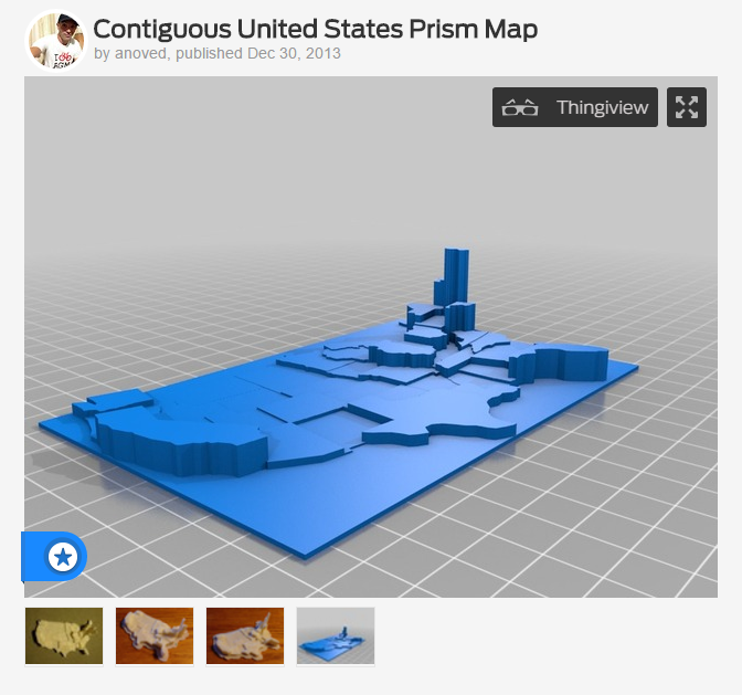
Then, in our effort to learn more about the local 3D printing community, we attended a workshop at the Maker Lab in the Harold Washington Library in Chicago. There we saw a printout of the topography of the bottom of Lake Michigan. We were also introduced to the idea of using 3D printing to display data. An example of this type of use can be found on a 3D printing site called Thingiverse where the user anoved has uploaded a model of the United States to be used to visualize data sets for the states. A screenshot of anoved's Thingiverse page with the map is shown below. We can imagine an agency using this model for public education to show the amount of transportation funding spent by each state or the number of highway fatalities or miles of roadway.
I'll continue to share our experiences with 3D printing as we learn more about the technology and increase our understanding of how it might fit into civil engineering. In the meantime, if you are interested in learning more, I'd encourage you to check out the classes on Coursera – they are free to take if you are not interested in earning a certificate for the specialization. You can also visit Maker Labs in your own areas – they are usually found in most larger cities, particularly in libraries. Also, if you know of any uses of 3D printing in our industry, we'd love to hear about them – just drop us an email, comment below, or reach out to us on social media.
