Improving Bicycle Path Design

Over the last year or so we've logged significant mileage on our bikes. While one outcome has been the expected increase in personal fitness, another has been better awareness and insight into design of bicycle facilities. Most of the paths along which we ride have been in place for many years so were probably designed under older guidance, but I am still not sure that all of the issues we've noticed have yet been addressed by more recent bicycle design manuals. So I wanted to share a few of the problem areas we have identified to see if anyone else has figured out or has any comments for some best practices or guidance to improve these aspects of design:

Tree impacts to the path

Root Damage on Bike Path

A lot of off-road paths are lined by trees. This can create a few issues that could cause a cyclist to fall and possibly be injured. This can occur in the colder climates because trees drop leaves that can pile up and become slippery if not cleared. Trees also drop seeds such as acorns or walnuts. Hitting these the wrong way could cause a cyclist to lose balance and fall. I know of at least one agency that regularly sends out a small sweeper about once a week to clear debris, particularly in the fall and that maintenance activity appears to keep the path in that area fairly clear.

Trees can also cause damage to the path from roots. As you can see in the photo here, someone has marked areas of the path where trees have caused the path to heave. If a cyclist did not see these bumps, they could lose balance and fall.

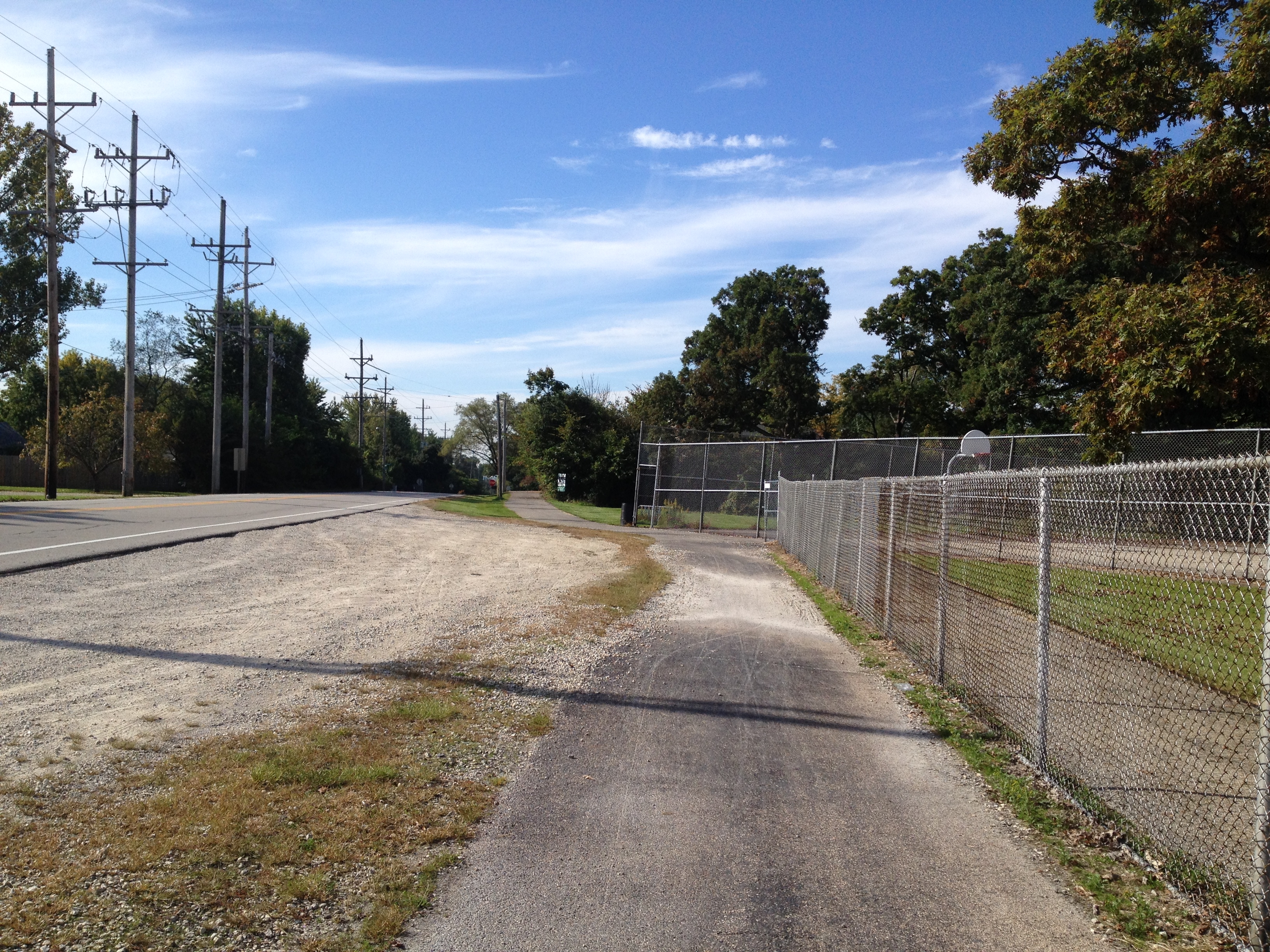
The tree's proximity to the path can also cause a potential for problems. As shown in the photo, trees are often located very close to the pavement. If too close, the trunks of the trees can also grow into the pavement. One day when we were riding in another area of this trail, we saw a cyclist miss navigating a curve and hit a tree that was very close to the path. He fell and fortunately was not hurt. But it made us wonder if there should be a clear zone for bike paths similar to the concept used for roadway design. The Washington State Shared-Use Path Design Manual does call for a horizontal clearance of two feet (page 1515-5). 

Roadway approaches

A lot of the trails we ride follow a river so quite often we end up having to navigate steep slopes when the path changes course away from the river. There have been a few instances where it seemed the designer could have mitigated the slope by lengthening out the transition, but instead took the shorter route which resulted in a slope almost steep enough to require us to dismount and walk our bikes. We've also wondered why when a bike route we follow is moved onto streets, the steepest street in the area is chosen for the route. One of the roads we ride along is so steep we definitely have to get off our bikes and walk them a block or two until the route turns down another, flatter street. I realize the calculation for bike level of service does not take into account grade – probably because it was developed in Florida along flat routes – but if I have to get off my bike, I am no longer able to use it as a bike route which would seem to mean a complete failure of that bike facility. So I definitely believe grade should be incorporated into the Bike LOS calculation. 

The other problem with steep slopes is that they require a lot of energy and momentum to ride up. And because many paths we bike along seem to have been designed with a steep slope immediately adjacent to an intersection with a road, we end up going up the slope approaching the road at a high rate of speed and with a lot of momentum then have to slam on the brakes immediately as we hit the road. I always wonder how we appear to the cars that are approaching the crossing. I would think it looks like we are not going to stop. The other problem with this design is there is usually no flat area at the top of slope at the road intersection. So as you wait for the cars to go by, you are sitting on that steep slope which makes it even more difficult to start moving again and quickly pedal across the road. A better design would seem to be to pull back the slope slightly and allow for a flatter area at the top where the path intersects the road. The question would be what distance would work best here? Another consideration would perhaps be to give a widened area at these intersections to allow for several users to queue while they wait to cross.

The other area where slopes seem to cause problems is at stream crossings. On the paths where we ride, there are many of these crossings and usually the downgrade is very steep on both sides of the bridge. So the ideal approach would be to ride fast down the hill and across the bridge so we have enough momentum to assist in making it up the hill on the other side. Unfortunately most of the designs have brought the slope down almost to a "V" at the edge of the bridge instead of designing in a gradual vertical curve. And because the joint where the asphalt path meets the bridge is not always smooth, we end up having to reduce our speed to make it over this severe change in grade that might also have a bump. So the only distance we have to build up speed again is across the short bridge which usually isn't enough.

Sight distance

It seems that there is some guidance out there for sight distance, but that doesn't help riders on paths that were built with no thought to this design consideration. Perhaps on older facilities, agencies responsible for the paths could go back and assess their facility and add in striping or signs to let cyclists know there are potential sight distance problems in a specific area.


Adjacent surfaces

Surface material of areas adjacent to bike paths can cause damage to the path or unsafe conditions for users of the path. For example, one trail we ride is located next to a gravel parking lot near a school. After riding through here a few times, we've gotten to the point where we now remain in the road through this section because there is always a lot of gravel on the path. This appears to be due to the drainage design and grades of the road, lot, and path in this location. As water flows from the road and across the lot, it picks up gravel from the parking lot. Then as the water flows across the path, the gravel drops out onto the asphalt, possibly because the path looks like it could be a localized low area. The gravel on the path is difficult to ride over and can cause instability to a cyclist which can result in them falling and possibly getting injured.

Gravel along bike path

Path Material

Path material is definitely an important component of a bike path. There is a path we ride along, or I should say used to ride along, where the agency decided to place asphalt grindings over the crushed gravel that was initially placed as the surface. Grindings are definitely a material that should never be used for a shared used path or even a dedicated bike path. There are usually few fines in it unless it has been processed to have fines added which usually isn't the case. So riding along a path made with grindings ends up somewhat similar to the experience of riding on marbles. We also came across another path where an agency had placed sand. Riding in sand is also not very easy. So as you can see in the photo below, people appear to avoid it by walking their bikes through the grass which is exactly what we did. The FHWA provides some guidance on surface materials for shared-use paths as part of their Designing Sidewalks and Trails for Access Part II of II: Best Practices Design Guide.

Bike Path with Sand


Signage
 
Another issue we noticed along many bike paths is a lack of directional signage. One day last year, I decided to go on a 30+ mile bike ride that took me along many routes with which I was not familiar. One particular route required me to transition between trail and roadway several times. Unfortunately it was difficult to navigate using my phone since it was having battery issues and didn't make it through most of the trip leaving me stranded with no map. Fortunately there was another cyclist who knew exactly where to go to get off one trail, make our way through a maze of streets and connecting trails and manage to end up where two main trails picked up again. And he was nice enough to realize I was lost and needed his guidance. Just a few well placed signs would have really helped me find my way because I really can't go biking on a regular basis hoping there will be a nice person there who knows the way and will help.
 
 
Share

Using Augmented Reality to Visualize Engineering Designs

This week I experimented with using an augmented reality app at a public meeting to display this simple visualization of one of our projects.

3D model of a project using Augmented Reality

My experience was that it did seem to help with explaining or showing people not only an overall snapshot of how the roadway will look when finished, but it also helped show specific design and operational details that were difficult to describe. So I figured I'd post a quick explanation of the software I used to create the model and which app I used to host and display the visualization in case anyone else is interested in trying something similar out at their own meetings.

To begin, I would have liked to just export the project directly out of CAD and into the program where I assembled the 3D model because this allows for a more accurate representation and saves some steps. I've done this before using AutoCAD, and it was very straight forward and easy. Unfortunately we use Microstation at work instead of AutoCAD and so far I have been unable to find a way to get this to work with that software. The main problem seems to be that although it has 3D export capability, the program will not allow me to export something with a thickness so everything ends up flat. And it won't let me expand my export in the "Z" direction even if I import it into other 3D programs. I've spoken with a representative of the company, and as I've indicated in previous posts, he said Microstation is not interested in supporting this because they don't see a need for engineers to use this type of feature – as he put it "we're engineers, not gamers." So because of this, I had to create the 3D objects in other programs and use a PDF of the plan view as a guide in placing the objects. Also because of this and my time constraints I only modeled a portion of the project where there were no complex shapes.

So the program I used to create and assemble the 3D objects is Opensimulator. It's a free, open source program that runs as a web service and allows you to create and texture 3D objects then export them as models. You can set up Opensimulator on your own desktop by using something like SimonaStick or you can run it by installing it on your computer and connecting it to a service that allows you to access the interface with the use of a viewer. I used the second option and connected it to a service called OSGrid then used the Singularity viewer to log in and build. The main difference between building with this method and one that would use a more traditional 3D program like Blender is that building in Opensimulator is much more intuitive because you create using an avatar or 3D representation of yourself. Opensimulator has also greatly simplified the creation and texturing of objects.

Here is an "aerial view" of what my "build" looked like inside OSGrid right before I exported it as a 3D model.

As a side note, what is nice about building in Opensimulator is that you can use your avatar to walk through the project and get a feel for how it will function. If we were also building a streetscape, the use of an avatar helps assist in placement of elements. And from what I understand, if I had an Oculus Rift device, I could have put it on and immersed myself in the design as if I was actually there. This is something I hope to also eventually try as a design tool once I get a chance to buy one of those devices.

The only elements in the photo above that I could not create in Opensimulator were the cars and curbed medians. As you can see from the attribution note in the photo, the cars were 3D models I downloaded from the Kator Legaz website then uploaded into Opensimulator using Singularity. And I also uploaded a median that I created in Blender because I wanted the top to be curved like a regular curb is – Opensimulator does not allow for the creation of something like this so I had to use Blender then import the 3D model into Opensimulator. For all the graphics or textures applied to the models, I created them using a graphic software package then uploaded them into Opensimulator. There are many graphics programs that I use, but if you are looking for a good, free program, you can always use Gimp.

Once everything was assembled, I used the export 3D model feature in Singularity to create a Collada file of my build. Then I used my account on Augment to upload the model so I could access it and view it using the Augment app on my iPhone and iPad. Having the model available at the meeting made it convenient to show people what it will look like when built. For example, when I was having trouble explaining how the inlets impact the bike lane, I was able to just use this model to show someone how the inlets effectively reduce the bike lane from 7.5 feet in width to 5 feet if people do not want to ride over the inlet. Overall I would say having the model did enhance the ability to share our project with the community, and I hope to be able to build upon this experience to create more complex and detailed models in the future. If you want to check out the model yourself, you can access it here:

3D Model of Protected Bike Lane

Share

Submit Your Ideas on Transportation & Assistive Devices & Technologies

Pedestrian and Signal Technology

The U.S. DOT through the FHWA has opened a dialogue on Transportation and Assistive Devices and Technologies. You can visit their Ideascale site to offer your own ideas about how best to make use of technologies to enhance and support mobility for transportation users with disabilities.

It's important for all of us in involved in roadway and signal design to remain involved in dialogues like this so that new technologies can be integrated in the most efficient and effective manner. Even if you don't want to comment or offer an idea, it's helpful to read through the ideas and comments to learn what those who use facilities we design really need. And there are a few comments that lead to other resources and tools which might be useful to planners and designers.

I offered one idea we've been discussing since visiting a community that had an older APS installed at an intersection. We noticed the voice was difficult to hear and understand. I want to add though that neither of us have a vision impairment so our observation was made as users who often rely on our sight for guidance and therefore could be different that the opinion of a person with a vision impairment. (You can watch a short video we took of the cycle to listen yourself to what a pedestrian would hear at this intersection.)

Other than the inability to really hear and understand what is going on from these devices, we are also aware there is concern about the constant noise created in the environment. While this is useful and necessary when needed, is it best to have a device that continues to make noise in the environment even when not needed? Especially when it begins to compete with other signal device sounds in a highly dense, and urbanized area? 

Before smart phones these were perhaps our only solution and therefore necessary, but now with smart devices, we wondered if it wouldn't be better to have pedestrian signal devices communicate directly with smart phones or devices. The APS could activate only when sensing a device that is programmed to request specific information from the APS such as location of button, path guidance, and area location information. If a path or destination had been programmed, perhaps the APS could even signal to the user which direction to go or if they are on the wrong street.

We also talked about installing something in the pavement along both edges of the crosswalk that could communicate with a pedestrian and let them know through vibrations or a pulse they were wandering outside of the crosswalk area.

Since exploring these ideas, we have not yet had the chance to discuss it with anyone who has a vision impairment which is why the dialogue is so important. Perhaps there are issues with our ideas we have not considered since we are primarily the designers and not the users of these devices. So I encourage everyone to take just a few minutes to visit the site, read the ideas, submit your own if you have them, add some comments, and work together with everyone to increase the use and mobility of our designs for everyone. 

Share

The Game is On – FHWA is Seeking Your Input on Smart Cars

USDOT Connected Vehicles ImageThe USDOT and several other transportation agencies around the nation have been paying close attention to the emergence of the smart car. Over the last few years, they have funded research in this technology and studied how to integrate it into the existing system. And now, they are reaching out in several ways to share what they have learned and seek input from the public and other professionals to help develop guidance for connected vehicles. Here is an excerpt of the notice from FHWA:

"The Federal Highway Administration plans to issue deployment guidance on connected vehicles to transportation infrastructure owner/operators in 2015. Your input is needed. Tell us what would best support decision making and deployments at the state and local level."

You can read more about this effort and access the link to provide your own thoughts and ideas at http://www.its.dot.gov/connected_vehicle/fhwa2015_connected_vehicles.htm. (The link to provide input was not working for me so if it does not for you, here are the email addresses it is set up to link to: Robert.Arnold@dot.gov and Cynthia.Maloney@dot.gov.) FHWA also collected public input at a session held on Jan. 16, 2014, in Washington, D.C. As the proceedings from that meeting become available, they will also be provided at that site.

Before providing input, FHWA suggests people read an article in Public Roads, Linking Drivers and Roads, to get more background on the technology and potential benefits which include the ability to:

  • deliver more accurate and robust hazard warnings to drivers
  • collect data for use in improving the transportation system
  • deliver vehicle location and speed information to traffic signals to adjust phasing and avoid vehicle idling
  • deliver road conditions to State and local agencies to help improve maintenance and service
  • deliver traffic and transit information to help travelers select optimal routes
  • provide specific, dynamic warnings that are more reliable than static signs and more likely to capture drivers' attention
  • provide invehicle alerts to drivers about potential violations of upcoming red lights
  • alert motorists when it is unsafe to enter intersections
  • alert the motorist to slow down if a driver's current speed is unsafe for traveling through an upcoming road curve
  • implement crash avoidance systems
  • inform visually impaired pedestrians of when to cross at intersections and how to remain aligned with crosswalks
  • allow for smartphones of registered blind users to alert traffic signal controllers and drivers to the presence of visually impaired pedestrians waiting to cross
  • enable granting buses priority at traffic signals based on factors such as number of passengers, schedule and headway adherence, service type, and peak direction of travel
  • provide travel information to commercial vehicle operators, including freight-specific route guidance, and facilitate coordinated load management to reduce empty-load trips
  • facilitate integrated transit operations, such as passenger connection protection, transit dispatching, and new forms of operational practices intended to enhance dynamic ridesharing

Another interesting section in the article summarizes the studies funded by FHWA and provides links to their findings.There are at least five other resources cited where you can learn more about this technology.


I've included a few more resources below for those who are interested in reading more about this technology:

USDOT Connected Vehicle Research Page: http://www.its.dot.gov/connected_vehicle/connected_vehicle.htm

Videos discussing connected vehicles from the opening session of ITE 2013 Annual Meeting and Exhibit in Boston, MA. http://www.ite.org/connectedvehicle/openingsession.asp

Tom Bamonte Twitter Stream (Tom regularly posts links to stories about driverless technology) : http://twitter.com/tombamonte


Share

Understanding Locally Administered Federal-Aid Projects

Construction of a Local Agency Federal Aid RouteLocal agencies have the opportunity to receive federal funds to spend on improving the federal aid routes in their communities. The challenge in taking advantage of these funds is that projects eligible for this funding must be designed and constructed according federal guidelines. And because of the many policies and procedures involved in the process, navigating through it all can be daunting for those who have never gone down that particular road. 

While state transportion agencies typically provide the oversight and approval of these projects and try to assist local agencies in successfully executing them, they often don't have the resources to teach everyone all the steps involved. So local agencies using their own staff are left to try to figure it out through trial and error or are left having to hire an engineering consultant familiar with this type of project.

So in an effort to help local agencies understand these projects and better navigate through the process, the Federal Highway Adminstration has launched an intiative to help ensure local agencies succeed in implementation of Federal Aid projects. This Tuesday, on September 24th, FHWA will host a webinar in the afternoon to offer more information about the program. If you work with Federal Aid projects, you'll definitely want to check it out!

Here is a link to the invitation with more information about where to sign up.

EDC2013LPA_Exchange_Invitation

You can also call  your local FHWA Division Office and ask to speak with the EDC Coordinator https://fhwaapps.fhwa.dot.gov/foisp/keyFieldFederalAidDivisions.do. And if you can't make it to the live webinar, FHWA indicated they will post the recorded webinar on the EDC website.

Share